Click Here To Download The Full Report
Rainfall To Become More Erratic This Week
By Drew Lerner
Kansas City, March 2 (World Weather, Inc.) – Rain concentrated on areas north of Sul de Minas during the weekend and the precipitation is expected to become more erratic during the coming week. Tuesday and Wednesday may be the driest days while precipitation late this week into early next week will be greatest from northeastern Sao Paulo into Sul de Minas. Temperatures will trend a little warmer this week especially while rainfall is lightest and most sporadic.
BRAZIL
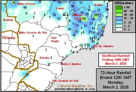 Rain Friday through Sunday afternoon was most concentrated on the region from Cerrado Mineiro to Bahia, Espirito Santo and Zona da Mata. Rainfall varied from 6 to 49 millimeters with one location in northern Minas Gerais reporting more than enough for local flooding. Sul de Minas was mostly dry except in the far west where one location reported 18 millimeters. Most other areas were dry.
Highest temperatures Friday through Sunday were mostly in the upper 20s and lower 30s Celsius followed by lows mostly in the upper teens and lower to a few middle 20s. Rain today and Tuesday is expected mostly in Bahia, northern Espirito Santo and in a few far northern Minas Gerais locations. Daily rainfall will vary from 5 to 25 millimeters with a few amounts to 45 millimeters. In the meantime, daily rainfall to the south will vary from nothing to 13 millimeters. Parana, Sao Paulo and Sul de Minas should be mostly dry.
An erratic distribution of rain is expected during mid-week this week with many areas failing to get 15 millimeters of rain and coverage of measurable rain may not be more than 30% of crop country. A boost in precipitation is expected at the end of this week and on into early next week with 5 to 20 millimeters expected with a few totals getting up to 35 millimeters. The greatest rain is expected from northeastern Sao Paulo through Sul de Minas to southern Cerrado Mineiro and Zona da Mata.
Temperatures will be seasonable over the next week to ten days with daily afternoon highs in the middle and upper 20s through the lower 30s with a few middle 30s possible after a few days of net drying. Most morning temperatures will be in the upper teens and lower to a few middle 20s.
World Weather, Inc. forecasts and comments pertaining to present, past and future weather conditions included in this report constitute the corporation’s judgment as of the date of this report and are subject to change without notice. Comments regarding damage or the impact of weather on agricultural and energy as well as comments made regarding the impact of weather on the commodity and financial markets are the explicit opinions of World Weather, Inc. World Weather, Inc. cannot be held responsible for decisions made by users of the Corporation’s information in any business, trade or investment decision.
©2025 World Weather, Inc. Any unauthorized redistribution, duplication or disclosure is prohibited by law and will result in prosecution.