Click Here To Download The Full Report
World Coffee Weather
Brazil Rainfall To Become More Erratic This Week
By Andy Karst and Drew Lerner
Kansas City, March 2 (World Weather, Inc.) – Rain concentrated on areas north of Sul de Minas during the weekend and the precipitation is expected to become more erratic during the coming week. Tuesday and Wednesday may be the driest days while precipitation late this week into early next week will be greatest from northeastern Sao Paulo into Sul de Minas. Temperatures will trend a little warmer this week especially while rainfall is lightest and most sporadic. Vietnam reported a few showers and thunderstorms during the weekend. The nation’s coffee areas are poised to receive more frequent rainfall during the coming week to ten days. The earlier than usual arrival of seasonal rainfall may induce early season flowering. In the meantime, rain also continues more abundant than usual in parts of Ghana and Ivory Coast and that will likely continue, as well, over the next ten days. India was dry and will remain that way for a while longer while showers occur sporadically in the Greater Antilles, Mexico and Central America. Peru, Ecuador and Colombia will all report frequent rain in the next week benefiting coffee and cocoa production areas.
BRAZIL
Rain Friday through Sunday afternoon was most concentrated on the region from Cerrado Mineiro to Bahia, Espirito Santo and Zona da Mata. Rainfall varied from 6 to 49 millimeters with one location in northern Minas Gerais reporting more than enough for local flooding. Sul de Minas was mostly dry except in the far west where one location reported 18 millimeters. Most other areas were dry.
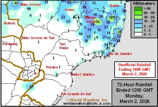
Highest temperatures Friday through Sunday were mostly in the upper 20s and lower 30s Celsius followed by lows mostly in the upper teens and lower to a few middle 20s.
Rain today and Tuesday is expected mostly in Bahia, northern Espirito Santo and in a few far northern Minas Gerais locations. Daily rainfall will vary from 5 to 25 millimeters with a few amounts to 45 millimeters. In the meantime, daily rainfall to the south will vary from nothing to 13 millimeters. Parana, Sao Paulo and Sul de Minas should be mostly dry.
An erratic distribution of rain is expected during mid-week this week with many areas failing to get 15 millimeters of rain and coverage of measurable rain may not be more than 30% of crop country. A boost in precipitation is expected at the end of this week and on into early next week with 5 to 20 millimeters expected with a few totals getting up to 35 millimeters. The greatest rain is expected from northeastern Sao Paulo through Sul de Minas to southern Cerrado Mineiro and Zona da Mata.
Temperatures will be seasonable over the next week to ten days with daily afternoon highs in the middle and upper 20s through the lower 30s with a few middle 30s possible after a few days of net drying. Most morning temperatures will be in the upper teens and lower to a few middle 20s.
COLOMBIA/VENEZUELA
Satellite imagery suggested rain and thunderstorms occurred in central and southwestern coffee areas of Colombia during the weekend. The majority of the precipitation was light to moderate with a few areas getting locally heavy rain. Actual reported rainfall varied from 3 to 20 millimeters with one location getting 80 millimeters. Most of the precipitation was light and northern Colombia and western Venezuela were left with a minimal amount of rain.
Periodic showers and thunderstorms are expected throughout Colombia and in portions of western Venezuela during the next week to ten days. Most coffee areas will get rain at one time or another and daily amounts should be light to occasionally moderate. The bottom line should continue favorable for coffee development.
PERU
Satellite imagery suggested showers and thunderstorms occurred in many areas across Peru Friday through Sunday. Coffee production locations were impacted with mostly light to moderate rain. Central areas were wettest and the bottom line was beneficial for most of the production region.
A continuation of daily showers and thunderstorms will impact coffee production areas in Peru through the next week to ten days. All areas will get rain and nearly all will see it multiple times. The bottom line should be quite beneficial for future coffee development.
PUERTO RICO, DOMINICAN REPUBLIC AND CUBA
Satellite and some surface weather observations suggested a few showers and weak thunderstorms occurred in a part of coffee country from Puerto Rico to eastern Cuba Friday through Sunday. Most of the precipitation was not very great, but that may change a little this week.
Additional showers and thunderstorms are predicted for the Greater Antilles this week and early next week. The precipitation will remain seasonably light and sporadic; although still present in portions of the region nearly every day. Most of the resulting rain will be quite light, but a few locations could end up with slightly more significant rain.
MEXICO AND CENTRAL AMERICA
Minimal amounts of rain fell across coffee areas from Mexico through Central America during the weekend. Totally dry weather did not occur in all areas, but the majority of crop areas were dry or experienced net drying conditions.
Weather conditions during the next week to ten days will include abundant sunshine; though a few pop-up showers and thunderstorms are expected as well. The precipitation will be random and mostly light having a low impact on the region. Eastern Mexico and a few areas from Guatemala into Honduras may be among the areas that get rain. Central and northern Guatemala to northern Honduras to eastern Nicaragua to areas in Panama near the Caribbean coast should be wettest.
IVORY COAST/ GHANA/NIGERIA/CAMEROON
Satellite imagery and surface weather observations suggested showers and thunderstorms occurred Friday through Sunday in much of central and southern Ivory Coast and in much of central and southern 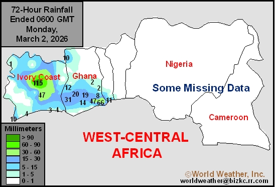 Ghana. Rain amounts varied widely up to 66 millimeters most often with 115 millimeters in a part of central Ivory Coast. Other areas in West Africa were unaffected by significant rain, although a few coastal areas of Benin and Nigeria did receive at least some moisture.
The greatest rain this week is predicted in Ivory Coast and southwestern Ghana. These areas will receive frequent rain. Sufficient precipitation is expected after weekend showers and thunderstorms occurred to induce new flowering and pollination. The bottom line will be favorable for both nations. A boost in precipitation will still be needed in southern Nigeria, southern Benin and parts of western Cameroon, although a few showers will pop up in those areas periodically with only light rain resulting.
VIETNAM
Earlier-than-usual shower and thunderstorm activity was noted in Vietnam and neighboring areas of mainland Southeast Asia during the weekend. The precipitation was a little sporadic leaving many areas dry. Satellite imagery suggested some rain may have also occurred in the Central Highlands along the Cambodia border.
An active weather pattern for this time of year is predicted for the next week. Showers and thunderstorms are likely often enough and with enough rain to induce some pockets of flowering. The precipitation should concentrate on central parts of the nation; although portions of the Central Highlands and the arabica coffee areas in the north may be impacted as well. Most of the resulting rain will be light with some occasional moderate amounts.
INDONESIA
Weekend satellite and surface weather observations suggested rain fell most significantly from 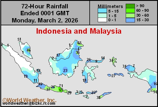 southern Sumatra through Java to the Lesser Sunda Islands. Some moderate to heavy rain resulted, although it was not widespread. A more limited precipitation bias was noted in central and northwestern Sumatra and in portions of Sulawesi where net drying resulted.
All of Indonesia will get rain at one time or another during the next week. Rain will fall frequently with many areas getting it over multiple days. The precipitation will be light to moderate and locally heavy most days with Java, southern Sulawesi and southeastern Sumatra among the wettest areas. Coffee and cocoa development should advance normally in this environment.
EAST-CENTRAL AFRICA (Ethiopia, Uganda, Kenya, and Tanzania)
Shower and thunderstorm activity continued from Tanzania north through Uganda and parts of southwestern Kenya during the Friday through Sunday period. Most of the precipitation was light to moderate, although satellite imagery suggested few stronger storms may have occurred as well. Ethiopia precipitation was more limited, although at least a few showers and thunderstorms occurred in western coffee production areas in that nation as well.
Not much change in weather is expected during the next week. Frequent rain will impact Tanzania, Uganda and southwestern Kenya. Some of the rain will be moderate to heavy and a few pockets of local flooding are possible. Rain farther to the north will be more sporadic and light; though many areas in central and some western Ethiopia locations will get rain as well.
INDIA
Southern India’s coffee region was dry during the weekend. The region is unlikely to see much precipitation during the next week. The few showers that pop up, however, will fail to produce enough rain to change soil moisture or crop conditions.
World Weather, Inc. forecasts and comments pertaining to present, past and future weather conditions included in this report constitute the corporation’s judgment as of the date of this report and are subject to change without notice. Comments regarding damage or the impact of weather on agricultural and energy as well as comments made regarding the impact of weather on the commodity and financial markets are the explicit opinions of World Weather, Inc. World Weather, Inc. cannot be held responsible for decisions made by users of the Corporation’s information in any business, trade or investment decision.
©2025 World Weather, Inc. Any unauthorized redistribution, duplication or disclosure is prohibited by law and will result in prosecution.